The Rutherford Ave/Sullivan Square Design is a transformative project to improve Sullivan Square and Rutherford Ave into a safe multimodal corridor.
The Charlestown Preservation Society’s feedback on the design plan follows:
The Charlestown Preservation Society Design Review Committee (DRC) appreciates the opportunity to provide comments on the evolving design for the Rutherford Avenue / Sullivan Square project at the 25% design phase. As a transformative, $200+ million public investment in neighborhood mobility, sustainable transportation, and the public realm, this project will determine how Charlestown residents, workers, students, and visitors move through and experience this corridor for generations.
As stewards of Charlestown’s historic character and community livability, we offer the following focused comments on transit alignment, connectivity and safe crossings, streetscape and public realm, and coordination with adjacent development at 201 Rutherford Avenue, the Austin Street Lots, and Bunker Hill Community College redevelopment. Our goal is to ensure that the final design prioritizes local streets first, discourages commuter cut‑through traffic into the neighborhood, and delivers a comfortable, safe, and inviting environment for pedestrians, cyclists, and transit riders while reinforcing Charlestown’s historic identity.
1. TRANSIT ALIGNMENT: SIDE PLATFORMS STRONGLY PREFERRED
The Design Review Committee reviewed two bus alignment options—central island platforms versus side platforms—and strongly recommends prioritizing side platforms for the following reasons:
Safety and Usability
- Pedestrian Safety: Side platforms eliminate conflicts between boarding passengers and through-traffic. Central island platforms force pedestrians to cross two travel lanes to access transit, creating unnecessary safety hazards, particularly for elderly residents, people with disabilities, and families with children.
- Bus Operator Sightlines: Side platforms improve driver visibility and reduce the risk of collisions with pedestrians entering or exiting vehicles.
- Walking Comfort: Passengers do not need to navigate across active travel lanes, reducing psychological and physical barriers to transit use.
Preservation of Public Realm
- Green Space: Side platforms preserve the ability to integrate substantial green infrastructure—street trees, bioswales, and planted medians—that support stormwater management, urban cooling, and neighborhood character. Central island platforms fragment green space and reduce tree canopy opportunities.
- Streetscape Coherence: Side platforms create a unified streetscape consistent with traditional Boston street sections and allow for continuous tree pits and ground-level planting.
Operational Flexibility
- Station Design: Side platforms simplify station shelter design and support integrated pedestrian amenities (seating, weather protection, wayfinding).
- Future Extensibility: The design should accommodate potential future transit expansion, requiring flexibility at station locations.
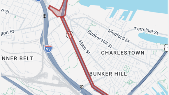
2. CONNECTIVITY AND SAFE CROSSINGS
Current design iterations lack sufficient pedestrian crossing opportunities, and do not do enough to minimize regional through‑traffic using local neighborhood streets as a bypass between suburban communities and downtown.
Grade Changes and Cross-Section Concerns
- Significant Grade Variations: Reported grade changes at the Austin Street intersection—including sections where northbound lanes may be elevated above southbound—create barriers to pedestrian movement and complicate universal accessibility. These engineering decisions require transparent explanation to the community and coordination with adjacent development at Bunker Hill Community College, 201 Rutherford and the Austin Street Lot site.
- The project should explicitly adopt a ‘local streets first’ traffic management and calming approach, limiting the appeal of neighborhood streets as a commuter bypass of Rutherford Ave into downtown Boston.
Pedestrian Crossing Strategy
Opportunities for additional pedestrian crossings and cut-throughs along Rutherford Avenue would restore north-south connectivity disrupted by decades of roadway design that prioritized vehicle over neighborhood access.
- Priority Crossing Locations:
- Gilmore Bridge approaches and Austin Street intersection, at-grade and relationship to planned developments and connection to Sullivan Square
- Connection points to existing Charlestown residential neighborhoods (e.g., City Square Park, Town Hill and Mishawaum blocks)
- Baldwin Street – to replace the temporary pedestrian bridge with a signalized crossing
Multimodal Enhancements
- Underutilized Pedestrian Asset: The Gilmore Bridge provides a critical connection between Charlestown and Cambridge. A new sidewalk on the southern side, expansion of the sidewalk on the northern side and a protected bike lane on the Gilmore Bridge would enhance pedestrian and bicycle connections.
- Sullivan Square, Rutherford Avenue, and the Alford Street/Broadway corridor in Everett. Current designs should expand sidewalk width and pedestrian accommodation at bridge approaches.
3. STREETSCAPE AND PUBLIC REALM
- The linear park and associated streetscape represent a historic opportunity to transform Rutherford Avenue from a highway barrier into a complete street that serves all neighborhood residents.
Street Tree and Shade Strategy
- Current Insufficiency: Narrow bridge sidewalks, corner features that lack vegetation, and underspecified shade provisions compromise the pedestrian experience and public health.
- Urban Forest Priority: Implement a robust street tree canopy strategy with:
- Mature, substantial shade trees (minimum 2.5″ caliper at planting)
- Adequate soil volume to support healthy root systems (minimum 800 cubic feet per tree)
- Climate-resilient species selection reflecting future temperature and precipitation patterns and road salt
- Spacing consistent with providing continuous canopy coverage
Public Realm Activation
- Intersection Enhancements: Corners at major intersections (Austin Street, Gilmore Bridge approaches) should incorporate:
- Substantial shade trees and seating
- Wayfinding that celebrates Charlestown’s historic identity
- Legible public space hierarchy distinguishing pedestrian areas from traffic zones
- Pocket Plaza (201 Rutherford): Any plazas created in conjunction with adjacent development should prioritize:
- Permanent shade (substantial trees, not temporary umbrellas)
- Active ground-floor retail frontage generating natural surveillance
- Public access and clear demarcation of public versus private space
- Accessibility and connectivity to transit stops
4. COORDINATION WITH ADJACENT DEVELOPMENT
The Rutherford Avenue public works project cannot succeed in isolation; it must be coordinated with planned land use, particularly at 201 Rutherford Avenue, the Austin Street Lot sites and Bunker Hill Community College.
Transit-Oriented Development Opportunity
- Context: The project coincides with PLAN: Charlestown initiatives and significant development activity, including the 201 Rutherford Avenue, Austin Street Lot and Bunker Hill Community College redevelopment. Rutherford Avenue’s redesign should support coordinated land use and housing growth while preserving neighborhood character.
- Principle: Transit-adjacent development should be integrated, not fragmented. Ground-floor retail frontage, at-grade pedestrian connectivity, and open space should function as a coordinated corridor.
Grade Changes and Development Site Implications●
Critical Coordination Issue: Reported grade changes near the Austin Street site must be carefully managed to ensure:
- Buildable, developable land areas for future redevelopment
- Appropriate frontage relationship between buildings and the public realm
- Pedestrian and vehicular access that integrates with the redesigned street
- Coordination with stormwater and subsurface infrastructure
5. HISTORIC PRESERVATION AND CHARACTER
The project should acknowledge and support Charlestown’s historic identity through thoughtful design integration.
Wayfinding and Public Realm Identity
- Neighborhood Recognition: The project is an opportunity to celebrate Charlestown’s distinctive character—Revolutionary-era heritage, 19th-century streetscapes, local institutions, and current community identity. Design elements should include:
- Wayfinding that connects transit riders to neighborhood landmarks, businesses and attractions
- Public art or commemorative elements that celebrate local history and identity
- Material and landscape choices that echo neighborhood character (e.g., brick, scale, planting traditions)
- Public art, planting, and material choices that reflect neighborhood heritage and community values
Community Continuity
- Pedestrian Connections: By improving walking access and creating a safer, more inviting street, this project can restore the neighborhood continuity fragmented by decades of highway-focused design.
SUMMARY: NEXT STEPS AND PRIORITIES
The Charlestown Preservation Society Design Review Committee supports this critical infrastructure investment and offers the following prioritized recommendations for the 50% design phase:
1. Finalize side platform configuration for bus transit alignment and detailed urban forest strategy
2. Provide comprehensive cross-section drawings showing grade changes, pedestrian crossings, and universal accessibility provisions
3. Develop pedestrian crossing strategy with minimum 3–4 new crossing locations that strategically connect the neighborhood across Rutherford Ave
4. Coordinate with adjacent development addressing grade changes and publicly activated building frontage at ground floors
5. Specify detailed urban forest canopy and green infrastructure standards
6. Design corner plazas and public realm nodes with authentic activation potential
7. Create public realm and streetscape design guidelines
8. Develop wayfinding and public realm elements celebrating Charlestown identity
CONCLUSION
The Rutherford Avenue / Sullivan Square project represents a generational opportunity to replace an auto‑oriented highway edge with a complete street that serves Charlestown’s residents, businesses, and institutions. If designed with a local‑streets‑first approach, it can reduce commuter cut‑through traffic in the neighborhood, restore neighborhood connections across Rutherford Avenue, and create a greener, safer, and more welcoming public realm that reflects Charlestown’s historic character.
The Charlestown Preservation Society looks forward to continued collaboration with the City of Boston, MassDOT, and our neighborhood partners as the design advances toward the 50% phase and beyond. We stand ready to assist in refining transit alignment, crossings, streetscape, and development coordination so that this significant public investment delivers lasting benefits in safety, connectivity, and quality of life for the Charlestown community
If you are interested in following the development of this project, you can sign up for email updates directly from the City.
Contact Us
Interested in learning about the history of Charlestown, or getting involved? We'd love to hear from you!