Main Street
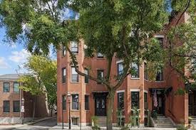
Main Street dates back to the 17th century. It was laid out in 1629 and called Country Lane, in 1714 it was Market Street, and Main Street by 1769. It was altered and straightened from the corner of Water Street nearly to the Neck or causeway in 1780. Maps showing Charlestown at the time of the Battle of Bunker Hill in 1775 indicate that structures were scattered along Main Street’s entire length with a node of houses at “Mill Village” (at or near the junction of Main, Mill and Eden streets). The completion of the Middlesex Canal at Charlestown Neck in 1803 and construction of the State Prison in the vicinity of what is now Bunker Hill Community College, encouraged development along Main Street during the early 1800s. During the 1840s Charlestown experienced a building boom related to the waves of Europeans-particularly the Irish-who settled in Boston and vicinity. Main Street was once lined with 1840s-1860s wood frame and masonry commercial blocks in the Greek Revival and Italianate styles, however, neglect and 1960s urban renewal resulted in the demolition of many of these buildings, particularly between School Street and Sullivan Square.
Included in the survey are 24 houses, built between 1790 and 1884:
- One wood frame late Georgian house (1795).
- Two wood frame late Georgian/Federal houses (1790-96).
- One masonry Federal house (? 1796-1806).
- Six Greek Revival houses – one masonry (1845) and five wood frame (1835-1851).
- Eleven masonry Italianate row houses (1855-1884), and three masonry Mansard row houses (1865-67).
There are fourteen commercial or commercial/residential masonry buildings:
- A Federal/Greek Revival/Boston granite commercial block (1828-29).
- Seven Federal buildings (1808-1830).
- One Italianate/Mansard commercial block (1856-7).
- Two Mansard commercial or commercial/residential blocks (1855-1875).
- One astylistic commercial/residential building (1891).
- One Renaissance Revival commercial building (1892-1901).
- One large Art Deco/Tapestry style former candy factory (ca. 1925).
*Information drawn from Boston Landmark Commission’s Charlestown Historic Resources Study 1981 (E. W. Gordon, Consultant), with the addition of photographs and images from early maps and/or the Mallory Panoramic View of Charlestown, when appropriate.